|
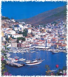
In spite of the fact that the name Hydra bespoke the island's wealth in springs in the past, today it is a rocky, arid and thirsty land. A road runs up from the town to the convent of Agia Matrona, dating from 1865, a characteristic example of the island's monastic architecture.
|
|
Eros
peak offers a panoramic view of the harbor and
of the Saronic Gulf in one direction and of
the Myrtoon Sea in the other. North of Cape
Rigas, on the Bay of Agios Konstantinos and
around the chapel of the same name, potsherds,
from the Mycenean up to the after Roman era,
were discovered since it had been the island's
harbor for the ships sailing in Cyclades.
There are two ways of getting to Kammina on
foot: after you climb the stairs in Navarhou
Kriezi Street, and pass the square building
of Hydra's central market, go down the gully
towards the great Kamini. The other way is along
the seaside.
Setting out on the left side of the harbor and
walking along the seaside, a distance of half
an hour, will lead you to the small, picturesque
port of Vlihos.
The medieval bridge on the road to Molos and
the medieval ceramics that were found in the
area, are evidence that the region was never
uninhabited. An unpaved road from Molos leads
to the country houses of Episkopi, surrounded
by a wonderful pine forest.
|
|